So agreeing to go we started discussing where we would go, throwing out suggestions of ones we had done before such as Macquarie Pass or Brokers Nose. I told Dad to leave it with me, feeling like I'd like to do something I had never done before. So I sat eating my leftover jalapeño stuffed-crust pizza for breakfast and a hike I had been wanting to do for ages came to me.
 |
| Previous night's dinner |

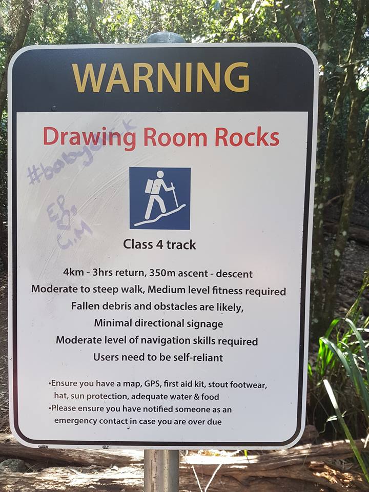
He told me that he had just woken up last night and it had been bleeding. I told him that he shouldn't be hiking with me but should be going to the Doctors. He waved it off as not being a big deal and I said "Well, you're 65 and your 26 year old son is telling you what you should do, but you're old enough to make your own decisions" and so I left it at that and we headed along the highway, out through Dapto, and to the end of Bong Bong Road where we saw the hikes starting path to our left.
We parked up and began our hike straight uphill.

It is a steep rocky walk through through cleared lantana, and in the hot sun I instantly regretted having worn pants instead of shorts.

We noticed tracks in and our of the path wondering if this is where people had walked through trying to find the Lockheed Hudson. However we also noticed tracks that looked like the paths were probably made by deer in the area.

So the path began to bend around and we noticed a fence to a left leading up to a big gate in front of us.


We continued to our right, following the path noticing some old crumbled steel I assume was an old water tower, but seeing it at a distance, I got my hopes up that it would be the plane.


Pushing further on up hill, already soaking with sweet and continually having Dad tell me I should have worn shorts we passed a turn off to our left.

Shortly past here we reached a fork in the path. One continuing the steep incline, the other, off to the right, blocked by a fallen down tree.


We decided to continue upwards, saying that if we had time we would explore down the blocked path on our way back.
After a very steep slope the path began to even out for the first time during the walk.

You could feel the climate change walking through, as the bush slowly became rainforest.


Continuing along there was a small break in the trees to our left letting me lookout over the Illawara facing towards Albion Park.

The path continued on with a steep rocky cliff on our right and a sharp fall into a gully on our left.


Shortly after this around a bend the path opened up, and Dad noticed paths going up to our right we he wanted to quickly explore before continuing up the path. Dad placed his backpack down, assuming it'd be a quick look, and we climbed up.


Upon reaching the top there was a little enclosed grassland with a banksia tree, so we headed to our right, (facing back down the trail) and headed to the edge of the cliff face.


Many bees were flying around the ledge drinking from little puddles of water in the rocks. We continued climbing upwards around the ledge, wondering if up here was he site of the plane crash.

Just as we reached the top we had to walk through a thicket of grass trees, before finding a very small track leading us to a beautiful view overlooking the Illawarra.
 |
| Xanthorrhoea |
 |
| Overlooking Lake Illawarra |

We followed the cliff edge all the way until we were looking towards Northern Illawarra, leaving Dad I walked into the bush hoping I might stumble upon the remains of the plane, keeping an eye open in case of snakes.

I continued walking though random scrub for about 10 minutes before deciding I'd just be wasting my time wandering aimlessly through the bush, and began heading back when I heard Dad calling out saying he'd found a path. I cut through the bush heading away from the cliff face when I came onto the track Dad was on.

We continued walking on this wondering out loud how long this path would go on for as Dad's backpack was still down the bottom. Dad said he believed it'd be a loop trail and probably link back down to where his bag was. Soon we opened up onto a big fire trail, we decided to head left on it to see if it did link back saying we could always run up the other way after we grabbed his pack.

 |
| Is it even a bushwalk without a termite mound? |

Feeling a bit awkward and uncomfortable we noticed a path to our left heading down with a big sign in front of it which was at the top of the walk had we taken the other path.

We were heading down this path for less than a minute before I spotted Dad's backpack. We quickly stopped for a drink and I ate my trail mix (goji berries, almonds, peanuts and cacao nibs) for a pick me up and we headed back down to explore the other path blocked by the tree lest we accidentally got ourselves a whopping fine.
Jumping over the tree, I turned on my phone for a quick google search of a location for this plane, really wishing to find one, for my sense of adventure and two as a lover of history. I soon found a video of people walking to it, a clear segment showing them walking down this path, however as the video was cut and from years ago I only new I was heading the right direction, the rest would really be up to luck. Heading down here there was an abundance of dendrocnide, the giant stinging tree that I reminded Dad about (as I have on other occasions).

To my right it looked like the land had slipped away or been cleared, whether this naturally occurred or was cleared by man I don't know. Soon we came upon again what looked like a path to our right heading down through some trees were you could follow the slope down to your left or right however while I was sussing it out Dad continued on forward and to the left which led into a little grassy area with a path leading around some trees to the right and heading forward in the direction of the original path, so I quickly followed him.

This path began heading downhill and for the first time I was glad I was wearing long pants as we walked through thick native raspberry bushes, orange thorn (Pittosporum multiflorum) and lantana.
 |
| Rubus rosifolius |
Continuing down through the scrub we saw an abandoned Satin Bowerbird nest underneath all the Lantana.

We continued on searching the bush for over an our to no avail.


We followed a few different paths believing they might lead us there, however they were sprinkled with poo. Including some square poos that I can assumed were left from Wombats. Our thoughts were given further evidence when one track led us to a cabbage palm that looked like it had been an animals lunch.

We decided we needed a change of tactics and so we separated. Dad heading up the hill and myself down, figuring we would cover more ground.
So instead of heading further in I began heading downward, wandering around searching for any sight of this wreckage. After about half an hour I stumbled upon a bunch of wires wrapping around an area. My heart began to race as I got excited believing that it had been placed around it to stop it being damaged or stolen by people.

However I noticed there was nothing inside, then I saw something sitting in the base of the tree trunk, a tub of something.. An uncomfortable feeling hit me as I looked around I saw another tub sitting at my feet.

I looked around, uncomfortably aware that my Dad was lost somewhere else in the bush, I decided to hurriedly move along back towards the road.
Hot and thirsty I came to a my a dense part of the bush, and rather than return to the wires I tried my luck at walking up a very soft dirt hill with incredibly loose topsoil. For every two steps I slid down a step, exhausting myself as I also tried to keep from sliding all the way back down.

At one point the soil gave way I went fell belly first into a bunch on native raspberry, thorns digging into my skin. I pushed myself back up and started using my hands, digging them into the soil to help pull myself up. I finally made it to the top, exhausted with my legs cramping. Looking up I realised there was more slope with this loose soil. It wasn't as steep up it continued along an edge, almost losing balance I at one point had to grab a hold of some orange thorn, ripping up my skin. Finally I made it to the top, coming up the left side of that slope I had looked down before falling Dad through to the grassy area earlier. I called out to Dad and luckily he wasn't too far away. He made his way down through the lantana, covered in scratches and blood himself. I told him about what I found and we decided to have a quick look down the right side after noticing one of the trees on top of the slope I had climbed has a small pink ribbon around it.

We didn't search long after doing a time check we realised that we had spent almost 3 hours just wandering through the bush (not including our initial hike up Bong Bong Pass). Tired and exhausted and feeling a bit defeated that we had not found the ruins of the crashed World War 2 fighter plane we headed back to the car, vowing one day we'd find out where exactly it was so we could see it.
EDIT/ 31/10/2021
After our walk to Madden's Falls and Kelly's Falls, my friend Tristan informed me that a guy from his work named Scott had permission to enter the property where the Lockheed Hudson crash site was (turns out it's on private property). He asked if I wanted to come with as him and his brother were going on Halloween. It was the day after my Wedding Anniversary, and I was a bit worried about the Covid risk due to being immunocompromised from my cancer treatment, but seeing as I was going to a restaurant in Sydney to to see Hamilton at Lyric Theatre I decided that those were more of a risk and so told him I would go.
Tristan picked me up early in the morning and we met at Reed Park car park. A surprising amount of people actually showed up to go (we were expecting much less). We soon began the walk up with the big group and I was instantly out of breath having lost so much fitness during my treatment. I was adamant to continue and we soon turned off the path that Dad and I had gone off trail hunting for it in.
During the walk the leader, Scott, said when people shared about it on Facebook and such (or on a blog), to let people know it was private property and that if people wanted to go see it, to either get in touch with the owner of the property or wait for an organised thing with permission with someone like him.
The track was no different than what Dad and I had travelled through, random bush, much of it with no clear path leading the way (if you didn't know what you were looking for, you would be very lucky to actually find it). While we walked Tristan asked if I would write a blog about it, with me saying I would just add an edit or amendment at the end of my previous Bong Bong Pass blog. "But you need to write more about me." He jested.

After navigating randomly through the bush, some of which I recalled from scrambling through randomly with Dad, we reached our first section of the remains of the plane.


As we continued down through the scrub we continued to see bits of the rubble.


Continuing down further we came to a section where two gunners and a navigator had died, and there they had a cross marking their names and positions.

The leader Scott told the stories about them and we continued a further short way down to the final spot through a section of heavily fallen palm fronds.
Scott told a story about the night of the crash back on November 4, 1942. He mentioned a place in Dapto where one of the men's watch was available to view and that it had stopped at the exact time of the crash, however I was up the back (trying my best to avoid exposure and couldn't make out all of that was said). We then took off our hats and had a moment of silence for those who lost their lives.
As the group made their way back up the mountain, Tristan, myself and his brother made our way down to see the site, noticing the plaques put there on a tree and that the tree had fallen over.


We made our way back up, following the lead of the people in front, contend I had the privilege to go and see a part of history.
Arriving back at the car park Scott said he would send anyone more information who wanted it. Tristan asked him to send it to him, receiving a video about the history that you can view HERE and a document about the history that you can read HERE.
If you have enjoyed this post, or my blog in general, please follow it, or like my page on facebook or follow me on Instagram.
Thanks for reading! - Steven
Extra tidbits! - The next day I decided to drive up to Camden with my Wife as I have wanted to visit for a few years now because my 4th Great Grandfather, James Sheather, moved there from England in 1839 to work on Camden Park Estate. And Sheathers Lane there had been named after him and his children.

We visited the lane before having a picnic at Macarthur Park, exploring the graveyard at St. John Church for his grave, and going to Camden Museum. We then drove out to Burragorang Lookout which was a beautiful sight.