Friday 29 September 2017

Brokers Nose

So yesterday I went for a bushwalk to Brokers Nose. Now, I've lived in the Illawarra my whole life, and while I had heard of it, I had no idea where it was. So after some googling, Dad and I set off to Wollongong, driving up Mount Ousley we took the Picton exit and took the first right to turn around and pull into the stopping bay just on your left, right at the top of Mount Ousley on the Princess Motorway.

Right off the side of the road
We began walking along the dirt track, curious as to how the walk would be.


We soon came to a split in the track, where the track either continued straight or turned off to our right. We decided to continue straight, assuming that would lead us to Brokers Nose and saying we would explore the other path on our way back.


We continued along the path which had slight inclines, and enjoyed the scenery.


After a while of walking you enter a clearing for powerlines, with a view over the city to your right.


You continue straight, following the dirt path, entering the bush again, and continue walking through here until you once again enter another clearing. We noticed to our left, a small little cross, which made us feel like we were in a Western Frontier.


And to our right, heading down the hill we noticed a track too, however we didn't take it knowing that the way to Brokers Nose was straight ahead.


After entering the bush and walking again, we soon came to another split in the road, one heading up to our right, the other staying flat on our left. Dad said he believed they would both lead to Brokers Nose, but the one on the right probably had some spots for sightseeing over the city, so we turned right, walking up the path, trying our best not to slip due to the incredibly loose top soil.


Soon even this path split again, we took the right path (that does lead you up to some spots where there are some views over the city), so it's worth the little walk up there before you cut back and continue up the other path.


The path continues uphill and we came across a big open area, which we believe that initial left turn would have taken you up to, however we never walked down either way so I can't say for sure.


Continuing up, the path then split again, 3 ways this time, much to our frustration, as we are the sort to like taking and walking every path, however we continued on straight.

Panorama view to show all 3 paths in the picture
There will soon be another path to your right, or you can continue straight (yes another split in the path!) however, both these will lead you out onto a dirt road which you follow right.


You continue up here to find yourself at some sort of radio tower, and then you're less then a minute away from Brokers Nose Lookout.


Coming up on the Lookout
There's an amazing view from up here of the Sea and the City and it's obviously been a popular spot of the years as the rocks are carved up with peoples names and dates.

Brokers Nose Marker

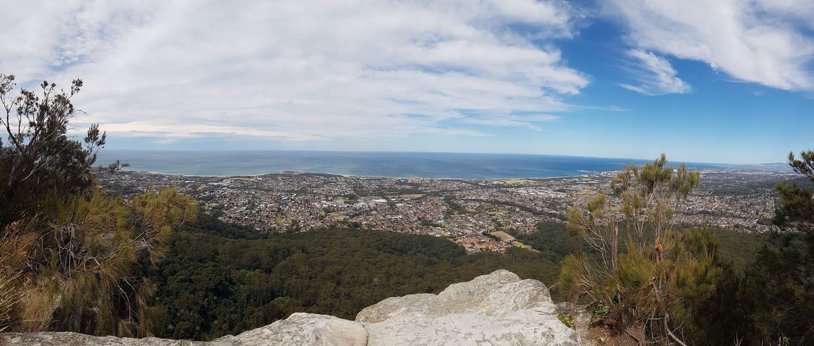
Panorama from the Lookout

There are some amazing looking rocks up here too.


Enjoying the Sights
We began our walk back, but rather than taking the first or second left, which would take us back the way we came, we waited and took the third which began leading us a different way, heading right through the bush. This walk went on for a while, until it opened us up into the clearing with the powerlines.


We followed this left, believing it would take us back to the point with the Cross. However it leads into scrub and we were unable to continue following along this path.


So we headed right, seeing another small path through the bush, which we followed. This leads you down into bush that was more like a rainforest.


We contiued along here, unsure of whether it would lead us back, or just head off to somewhere completely different.


Eventually after some ups and downs the path begins to steadily go down, while the rainforest gets thinner and becomes more like bushland before opening into a dirt path clearing which you can follow left towards the powerlines.


This path is lined with beautiful wattle and beautiful little yellow flowers.


This road soon splits, believing if we followed it left it would lead us back to the cross we continued straight, which has some steep sections to walk up, when you reach the end of this it heads both left and right, we followed it left for a short while which took us back to the very first clearing that the walk opens up to. Back on the original path we headed back, until we got to the very first split that this walk had given us, so we turned left to explore it a little before we headed off home.


You walk past a termite mound, which if you've never seen one you must have never walked in Australia. You soon come to a drop off, as the rest of this walk continues very steeply downhill.


As if going downhill wasn't bad enough, the path is littered with piles of leaves which slip under you as well as incredibly loose top soil, if you don't go extremely slow it would be very easy to slip and fall and roll downhill.

Dad sliding down the loose top soil
Also incredibly dangerous along here is that all around you are heaps of Dendrocnide. A stinging tree, so watch out and try not to touch its leaves as it grows along the side of the path and leaves litter the path too.


Dendrocnide
If you choose to walk here keep your eyes open for Deer, we heard a couple and only saw one which was running away from the loud noises we made as we slid and ran down the dirt slopes.


We eventually came to an open road with a sign by the side.


Just down the road from here this is a gate blocking it off saying private property.


Seeing it also had a sign on the other side I quickly jumped the gate to see what the other sign said.


Although there was still more dirt path heading down we assumed it would only lead into the backs of peoples houses, and after already having been walking for 3 hours we decided we'd try and make our way up the steep, slippery slope and draw our walk to a close. Again, I think it's amazing that so many walks exist just off the side of a road that you can live your whole life in an area and have never done it.

If you have enjoyed this post, or my blog in general, please follow it, or like my page on facebook or follow me on Instagram.
Thanks for reading! - Steven

Friday 22 September 2017

The Castle

So ever since I was a kid I had heard my Dad talk about The Castle, a mountain in the Budawang Ranges in Morton National Park. I have walked Pigeon House many times but The Castle walk sounded so grandious that it's always been a walk I planned to do.
Finally this year (July 30 2017) my Dad and I went away camping down into Morton and stayed at Long Gully to hike The Castle.
I was feeling like absolute shit (having been at my fiancée's work party and well over-drinking), however I made us up a nice fire for the night as we settled in, eager for our hike the following morning.

During the night as we sat around the camp fire and talked, mostly my Dad telling the story of how he had done The Castle before with Hash (Hash House Harriers) in the pouring rain and how they never made it to the top but the sights were incredible. As we talked we heard noises from the bush to realise we were being watched by two Brush Tail Possums, who soon came closer to our camp and were quite friendly. Enough so that I was able to feed and eventually pat them. 


However, I don't recommend letting them get too close as soon they were on our table trying to get too our food and one ended up chewing on the end of my finger thinking I had food in my hand.

That night the wind was howling, it was like a fighter pilot was taking off over our head all night. It was just the noise raging above us as the tent was not hit by much wind. The next morning, after not much sleep, we packed and began our walk.


After you follow the path for a little bit you soon come to a creek and have to look for the way to go as there is one sign post here, but well hidden and no more from this point on.

Photo (of my Dad) taken on the way back
You walk through a rainforest like area filled with cabbage palms for a while before the track begins to go up hill entering drier bushland. 

Termite Mound. A staple of every Aussie Bushwalk
It goes up and down a few times leading you to the base of the mountain, at this point the walk begins to be all up hill. Along this point, and just before you get to an incline (with some chains along the side to help you up it), we came across a little Lizard.


Just up this point you have a spectacular view already of the gully and Pigeon House Mountain in the distance to your left.


You begin heading left walking around the mountain and see many caves and Honeycomb rocks.


The walking track is quite easy from here, there are moments of uphill and climbing up little ledges but further along there is a decent amount of scrambling up and over and down big rocks, so if you're not confident climbing and scrambling this hike is not for you.


It continues on like this, climbing up ledges and trying to navigate the way, although there are arrows scratched onto rocks and trees along the way they can sometimes be hard to locate, so another system of finding the right way is looking for the knots tied into the plants by, who, I don't know, but Dad dubbed them "The Phantom Knotter."


You will eventually get to a pretty cave which Dad had told me that while walking with Hash in the pouring rain he found people huddled up camping in this cave out of the rain, and judging by all the fire places along there it must be a pretty popular spot.


Eventually you find yourself going up, not so much stairs, but wooden planks layering the soil so it's essentially stairs, there will also be some small wooden bollards along here too, while walking this I realised the back of my heel was getting rubbed raw from wearing old joggers that had worn down.


So I stuffed the back of my shoe with tissues and continued walking. You soon get to a cross roads where you can turn left to Monolith Valley (a walk I will have to do sometime) and right which takes you to The Castle.


Not far from here you reach a section called "The Tadpole Tail". I have no idea why, but you have to scramble over some rocks, squeeze through a cave and then crawl through the next bit.


You'll come out the other side and find yourself having to climb down a rope. 


Again you'll find yourself in the bush, no clear path so you can try to find your way, you'll have to go down and head right and as you walk along you'll come to a little shelter we dubbed "Licorice Rock" as we bumped into a couple here eating Licorice and it is a nice spot to have a little rest and eat. We stopped to take Dads insoles or 'gel pads' out of his joggers so I could place them at the back of my heel to stop the rubbing.


After this there is a lot more rope climbing, scrambling and from here on out I'm sure a lot of people would stop and not make it too the top as some of it is pretty hairy. Along this bit we bumped into 3 females who were lost and couldn't find the way to go, we found out they were professional rock climbers and we began to all make out we too the top.


Just after this there are some even steeper climbs and on the day it was absolutely howling with wind. We were exhausted and sore and we sure as hell didn't feel safe up in that gale, it was the sort of wind that blows you around on an average day just walking along the street, so being up that mountain we didn't feel comfortable and turned back while the rock climbers continued. However, disappointed we didn't make it to the top we went back and attempted again on the 15th of September 2017 (again camping at Long Gully and getting no sleep due to the wind). As we reached this point (the second time) we found a little had changed. The ropes looked a bit more worn and we found a lovely piece of it laying on the ground.


However the wind was on and off that day so when it'd died down we proceeded to continue the climb and make our way all the way to the top, hoping to sign our names into an apparent book that was on the top. I'd like to stop and just say how cool it is that my Dad (who is 64 years old) made it to the top.

Atop the Castle - Pigeon House/Didthul in the background
We found the plateau beautiful looking like something out of Arthur Conan Doyle's 'The Lost World'. We made a note of where we had ascended so we didn't get lost coming back, noting we'd come up right next to a little Xanthorrhoea (Grasstree). We proceeded to look around for the book to sign our names and complete our journey, however the apparent trails that were supposed to be there weren't, or were overgrown. We walked around the rim before we began to find piles of rocks which we realised were human made, we followed them assuming they would lead us to the book.


At one pile Dad stopped me, handing me a rock saying we should both put a rock on top. I looked down realising the one he was trying to hand me had a huge Huntsman Spider on it, when I told him he freaked and dropped it.
We both placed a rock on top and found they were all over the top but really only led to what looked like somones camp site. The wind then began picking up again and blowing an absolute gale, but we still spent an hour walking over the entire top, all around the outskirts and through overgrown scrub in the middle and were unable to find it. So I think it's safe to assume it's no longer there.

Panorama from the Top
We then tried to find our way down, even knowing what we were looking for we struggled. Eventually finding it we said we would get the heck down because the wind was that ferocious, there was just no rest to it. However climbing down we found ourselves terrified. One of the ropes is attached to a dead tree and in the wind the tree was moving and you could hear the roots pulling like it could snap at any time. It was definitely not safe and hopefully some new ropes will be put up and in a safer way. We eventually made it down having got to the top on our second attempt (even though the wind ended up worse than the first time we went). It truly is an adventure and an amazing hike. Hopefully I can go back soon and take the turn off to Monolith Valley and come back and post about it. The hike, including the hour walking around on top took us about 8 hours (although that was the second time, which was a cooler day and we stopped less on the walk up to look around and take photos or eat, also my foot was fine, so we powered through it). If you have a high level of fitness you might be able to do it faster, but it all depends on how much time you want to take (if you decide to attempt it!)

If you have enjoyed this post, or my blog in general, please follow it, or like my page on facebook or follow me on Instagram.
Thanks for reading! - Steven